


ROUTE
Page 28
If you've noticed an error in this article please click here to report it so we can fix it.
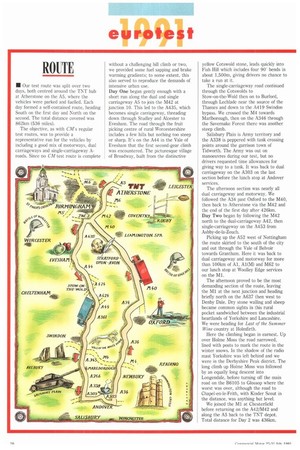
• Our test route was split over two days, both centred around the TNT hub at Atherstone on the A5, where the vehicles were parked and fuelled. Each day formed a self-contained route, heading South on the first day and North on the second. The total distance covered was 862km (536 miles).
The objective, as with C s regular test routes, was to provide a representative run for the vehicles by including a good mix of motorways, dual carriageways and single-carriageway Aroads. Since no CM test route is complete
without a challenging hill climb or two, we provided some fuel sapping and brake warming gradients: to some extent, this also served to reproduce the demands of intensive urban use.
Day One began gently enough with a short run along the dual and single carriageway A5 to join the M42 at junction 10. This led to the A435, which becomes single carriageway, threading down through Studley and Alcester to Evesham. The road through the fruit picking centre of rural Worcestershire includes a few hills but nothing too steep or sharp. It's on the A44 in the Vale of Evesham that the first second-gear climb was encountered. The picturesque village of Broadway, built from the distinctive yellow Cotswold stone, leads quickly into Fish Hill which includes four 90 bends in about 1,500m, giving drivers no chance to take a run at it.
The single-carriageway road continued through the Cotswolds to Stow-on-the-Wold then on to Burford, through Lechlade near the source of the Thames and down to the A419 Swindon bypass. We crossed the M4 towards Marlborough, then on the A346 through the Savemake Forest there was another steep climb.
Salisbury Plain is Army territory and the A338 is peppered with tank crossing points around the garrison town of Tidworth. The Army was out on manoeuvres during our test, but no drivers requested time allowances for giving way to a tank. It was back to dual carriageway on the A303 on the last section before the lunch stop at Andover services.
The afternoon section was nearly all dual carriageway and motorway. We followed the A34 past Oxford to the M40, then back to Atherstone via the M42 and the end of the first day after 426km. Day Two began by following the M42 north to the dual-carriageway A42, then single-carriageway on the A453 from Ashby-de-la-Zouch.
Picking up the A52 west of Nottingham the route skirted to the south of the city and out through the Vale of Belvoir towards Grantham. Here it was back to dual carriageway and motorway for more than 100km of Al, Al(M) and M62 to our lunch stop at Woolley Edge services on the Ml.
The afternoon proved to be the most demanding section of the route, leaving the M1 at the next junction and heading briefly north on the A637 then west to Denby Dale. Dry stone walling and sheep became common sights in this rural pocket sandwiched between the industrial heartlands of Yorkshire and Lancashire. We were heading for Last of the Summer Wine country at Holmfirth.
Here the climbing began in earnest. Up over Holme Moss the road narrowed, lined with posts to mark the route in the winter snows. In the shadow of the radio mast Yorkshire was left behind and we were in the Derbyshire Peak district. The long climb up Holnne Moss was followed by an equally long descent into Longendale, before turning off the main road on the B6105 to Glossop where the worst was over, although the road to Chapel-en-le-Frith, with Kinder Scout in the distance, was anything but level.
We joined the M1 at Chesterfield before returning on the A42/11,442 and along the A5 back to the TNT depot. Total distance for Day 2 was 436km.