


STAYING ON
Page 53
Page 54
If you've noticed an error in this article please click here to report it so we can fix it.
COURSE
Getting lost isn't just irritating — it wastes time, fuel and hence money, and reduces a fleet's operational efficiency. Fortunately, some new technology could make it a thing of the past.
• According to the Transport and Road Research Laboratory (TRRL), 6% of the distance covered by vehicles on British roads is wasted due to poor routeing. That implies an avoidable extra cost of some £2,400 million a year.
Though some of this wastage cannot be eliminated, journey times could be reduced by as much as 8-12% by helping drivers find better routes. In London alone, there are potential savings to be made of well over £100 million a year from better route guidance.
Such considerations led the Department of Transport, through the TRRL and with technical input from Lucas Industries, to develop the Autoguide systems in pilot form. Last September a DTp discussion document was issued, describing the potential benefits of Autoguide and other vehicle navigation and tracking systems already in pilot use or under development in other parts of the world.
REAL TIME
Advances in microelectronics and the use of computers in information technology have already led to improvements in the efficiency with which we use the roads, including the TRRL's work on traffic control in the 1970s and the innovative SCOOT system, which adjusts traffic light change timings in 'real time in response to the actual traffic conditions.
Navigation aids are already becoming available, but the potential for electronic route guidance is much greater. Through information transmitted to the vehicle from equipment on the roadside, the driver can be given route guidance based on up-to-the-minute traffic information. To realise the full potential requires the installation of roadside equipment and central computers and on-board transceivers.
The system's main advantage would be in connurbations where there are hundreds of thousands if not millions of vehicles, so London would be the natural starting point. It would be possible, says the DTp, to install a system in the area enclosed by the M25 by the early 1990s. It would provide the basis for expansion to other urban areas, to major inter-urban routes and, in co-operation with other countries, to international transport operation.
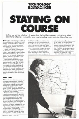
Route guidance has always been available from maps and signposts, but in a dense network like London there can be dozens of possible routes for a journey of just a few kilometres. Nowadays a computer can choose the quickest (or the shortest) route for a particular journey, based on its stored information on average journey times for each stretch of road. The TRRL has developed a prototype system — ROUTE-TEL — which uses a Dip database of information on main roads in England and Wales.
Such route-finding aids can help a driver to plan a suitable route before setting off, in the light of predicted road conditions. After that, apart from any radio broadcasts he might pick up, the driver is on his own during the journey if he gets lost, or traffic conditions deteriorate. Until now, that is, because electronics could be about to come to the rescue.
Aids to navigation do not necessarily provide direct route guidance, but may help drivers to keep track of where they are. Mechanical devices which kept track of a vehicle's location using dead-reckoning were the forerunners of recent electronic systems such as PACE, developed by the Plessey group. This displays a vehicle's position on an electronic map, based on data received from magnetic compass and odometer (distance travelled measurement) devices.
VOICE BOX
The Lucas Navigator system, developed with TRRL participation, is one example of such a device, which tells the driver, via a synthesised voice box, the distance to the next junction and the directions to be followed. Similar systems are being developed in Europe and the USA — the Dutch CARIN system from Phillips makes innovative use of a compact disc for storage of up to 150,000 A4 pages of map data.
Information can be passed to a driver during a journey in a number of ways. The most familiar of these is radio broadcasting. The BBC's motoring unit feeds the national network, and many local stations rely heavily on the AA's Roadwatch, as well as drawing on bulletins from the DTp's Road Information Unit about major roadworks, accidents and other incidents which may affect journey times.
Radio traffic news flashes and matrix roadside signs can help the driver decide on a route, either before or during the journey — but they all lack 'real time' information on traffic conditions as they actually exist.
Systems like Autoguide, however, work out the best routes in the light of actual traffic conditions. Roadside electronic 'beacons' transmit location and route guidance information to passing vehicles and also count the number of vehicles passing, as a guide to traffic density. By timing the movement of an Autoguide-equipped vehicle between two beacons in the network, speed (and hence flow) of traffic can be assessed. The beacons, or 'electronic signposts' are connected to a central computer which sifts the data and converts it into advice for drivers. Relatively low-cost units are needed in the vehicle, but the required extent and cost of a beacon network has yet to be established, says the DTp.
At the Traffex conference in Brighton earlier this month, Roads and Traffic Minister Peter Bottomley announced the go-ahead for an Autoguide pilot scheme involving five beacons set up in the Westminster area (convenient, at least, for MPs to inspect!) and one on the M4 to Heathrow. Twenty vehicles will be equipped with Autoguide's onboard equipment, comprising a fascia-top mounted 'route computer', into which the driver keys his starting point and destination.
Drivers taking part in the Autoguide experiment will be able to select either the shortest or the quickest (often not the same) route, or can select a 'no motorway' route.
Different routeing systems are built around different cost priorities, biased in some instances by the availability of existing products. Hence the use of compact discs by Philips and of a magnetometer adaptive compass (a piece of equipment already in production for the military) by Plessey. It follows that the apportioning of electronic intelligence between the roadside beacons and the on-board equipment for routeing or tracking is a matter of balanced, even political, judgment.
CROSS SECTION
Autoguide is intended to appeal to a wide cross-section of road users, the expensive hardware going into the becaons — which could be installed on traffic light posts and/or buried below the road surface, so the on-board route computer might cost only £150 at today's prices.
What of the benefits? Research by the TRRL, and the results of overseas experiments, suggest that in London, journey time savings would average about 10%. For a heavy goods vehicle covering 16,000km per year on London's roads these savings could be in the order of .Y600, which in the first year would comfortably cover the cost of the unit and what the DTps calls darkly any 'service charges'.
How heavy those service charges will be is certain to hinge on the number of users. The DTp reckons that an annual 'licence fee' of U0-g30 would be sufficient, if the owners of as many as 400,000 vehicles can be persuaded to join the scheme.
It is envisaged that a comprehensive Autoguide system for the area enclosed by the M25 would need roadside beacons at about 700 key road junctions. All major roads and heavily-used minor routes would be programmed into the system though 'rat-runs' through residential streets would, not surprisingly, be excluded.
ROUTEING SYSTEM
Recommendation of a particular route at a certain time to too many vehicles could, of course, defeat the whole object of a routeing system. Autoguide's central computer will continually update its assessment of conditions.
One of the latest systems to be announced is Datatrak, developed as a joint venture by Securicor and the Wimpey Group. it makes use of marine navigation technology employed in oil exploration work which is equally applicable to routefinding on land.
Though intended primarily to give the moment-by-moment whereabouts of a vehicle to a fleet operations centre, Datatrak can be tailored to give the driver navigational and directional information on in-cab electronic map displays and/or route indicators.
No roadside beacons are used by Datatrak. Instead it uses a network of around 18 low-frequency radio transmitters whose signals are received and processed by an in-cab locator, which is said to give the vehicle's position to within 50 metres in any direction.
The vehicle equipment uses an aerial only 40cm long. Both the aerial and the electronic unit can be hidden so that criminals will not be aware that a covertly stolen, or openly hijacked, vehicle is being tracked automatically.
by Alan Bunting