


LINKING UP VALLEY AREAS IN SOUTH WALES.
Page 10
If you've noticed an error in this article please click here to report it so we can fix it.
Road schemes of importance to motor vehicle drivers, in that the aim is to give better communications in the mining valleys, have been decided upon by local authorities of Glamorganshire.
It was reported to the Aberdare Urban District • Council that to enable the county council to proceed with the construction of anew road into the Aberdare Valley from Abercynon alongside the old Aberdare Canal, it was first necessary for the Mountain Ash and Aberdare Councils to acquire certain land. The new road will entail construction of a viaduct across the valley at Abercynon. It was agreed to make the purchase.
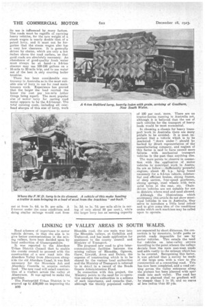
The Pontypridd Urban District is to expend up to V0,000 on improving the B26 Rhondda road, the one main way into the Rhondda valleys, at Gyfeillon and Trehavod, and has made application for assistance to the county calmed and Ministry of Transport. The proposed new road to give intercommunication facilities between the mining valleys of Rhondda, Ogreore, Garw, Liwynfi, Avon and Dulais, the expense of constructing which is to he shared by the various local authorities and the Ministry of Transport is referred to in detail in a record of the Roads Grants Administration Fund.
In connection with this project, the Ministry points to the need for co-operation amongst the authorities in a schema of such importance, and remarks that, a/though the thickly populated valleys are separated by short clitances, the connection is by mountain, bridle paths or parish roads impossible for use • by motor vehicles. This entails the need for vehicles on inter-valley service travelling to the point whence the valleys deviate from the main east-west roads and adds vastly to the mileage which has to be covered. Recognizing this factor, it was advised that. a survey be made of the large area with a view to the construction of a connecting road. This has now been completed, and a road cutting across the valley entrances along the plateau has been planned with spur roads into each v-alley. The road kis been so planned that no gradient will be steeper than 1 in 1.5, and no curve
less radius than 50 yds.