


Roads of the World
Page 46
Page 47
If you've noticed an error in this article please click here to report it so we can fix it.
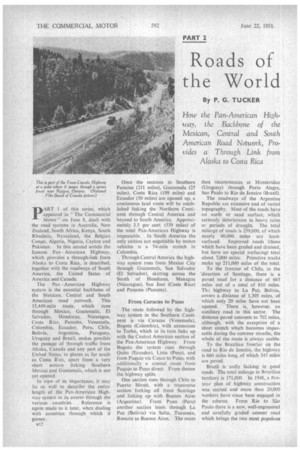
By P. G. TUCKER
How the Pan-American Highway, the Backbone of the Mexican, Central and South American Road Network, Provides a Through Link from
Alaska to Costa Rica
TART 1 of this series, which
appeared in "The Commercial Motor" on June 8, dealt with the road systems in Australia, New Zealand, South Africa, Kenya, South Rhodesia, Nyasaland, the Belgian Congo, Algeria, Nigeria, Ceylon and Pakistan. In this second article the famous Pan American Highway, which provides a through-link from Alaska to Costa Rica, is described, together with the roadways of South America, the United States of America and Canada.
The Pan-American Highway system is the essential backbone. of the Mexican, Central and South American road network. This 15,449-mile route, which runs through Mexico, Guatemala, El Salvador, Honduras, Nicaragua, Costa Rica, Panama, Venezuela, Colombia, Ecuador, Peru, Chile,
Bolivia, Argentina, Paraguay, Uruguay and Brazil, makes possible the passage of through traffic from Alaska, Canada and any part of the United States, to places as far south as Costa Rica, apart from a very short section linking Southern Mexico and Guatemala, which is not yet opened.
In view of its importance, it may be as well to describe the entire length of the Pan-American Highway system in its course through the various countries. Reference is again made to it later, when dealing with countries through which it passes. Once the sections in Southern Panama (211 miles), Guatemala (25 "miles), Costa Rica (199 miles) and Ecuador (50 miles) are opened up, a continuous land route will be established linking the Northern Continent through Central America and beyond to South America. Approximately 3.5 per cent. (539 miles) of the total Pan-American Highway is impassable. in South America the only section not negotiable by motor vehicles is a 54-mile stretch in Colombia.
Through Central America the highway system runs from Mexico City through Guatemala, San Salvador (El Salvador), skirting across the South of Honduras, Managua (Nicaragua), San Jose (Costa Rica) and Panama (Panama).
From Caracas to Puno The route followed by the highway system in the Southern Continent is via Caracas (Venezuela), Bogota (Colombia), with extensions to Turbo, which in its turn links up with the Central American section of the Pan-American Highway. From Bogota the system runs through Quito (Ecuador), Lima (Peru), and from Puquio via Cusco to Puno, with additionally a coastal route from Puquio to Puno direct. From thence the highway splits.
One section runs through Chile to Puerto Montt, with a transverse section forking off from Santiago and linking up with Buenos Aires (Argentina). From Puno (Peru) another section leads through La Paz (Bolivia) via Salta, Tucuman, Rosario to Buenos Aires. The route then recommences at Montevideo (Uruguay) through Porto Alegre, Sao Paulo to Rio de Janeiro (Brazil).
The roadways of the Argentine Republic are extensive and of varied topography. Most of the roads have an earth or sand surface, which seriously deteriorates in heavy rains or periods of drought.. The total mileage of roads is 259,000, of which nearly 40,000 miles are hardsurfaced. Improved roads (those which have been graded and drained, but have no special surfacing) total about 7,000 miles. Primitive tracks make up 211,000 miles of the total.
To the frontier of Chile, in the 'direction of Santiago, there is a paved road for a distance of 685 miles out of a total of 810 miles. Th:" highway to La Paz, Bolivia, covers a distance of 1,305 miles, of which only 20 miles have not been opened. There is, however, an auxiliary road in this sector. The distance paved amounts to 702 miles, although, with the exception of a short stretch which becomes impassable during the summer months, the whole of the route is always usable.
To the Brazilian frontier on the road to Rio de Janeiro, the highway is 660 miles long, of which 345 miles are paved.
Brazil is sadly lacking in good roads. The total mileage in Brazilian territory is 171,000. In 1948, a liveyear plan of highway construction was started and more than 20.000 workers have since been engaged in the scheme. From Rio to sao Paulo there is a new, well-engineered and carefully graded cement road which brings the two most populous
:hies of Brazil within about six hours af one another by car Concrete roads, however, are generally confined to the urban
Jistricts The Rio-Bahia highway, the trunk route between the road systems of North and South Brazil, carries heavy traffic. It is about no miles long and provides a through road from Jaquarao, on the Uruguayan border, to Fortaleza, in the northern State of Ceara.
Hundreds of miles of good road have been, and are being, built connecting inland cities with coastal roads, and with the trunk system which links North and South Brazil.
Unlike those in some South American countries, many of the roads in Venezuela have been provided with what might be termed improved surfaces. About 90 per cent. of the country's exports are derived from the oil wells, and this accounts for much of the road development which has taken place.
In Venezuela, connection with the Pan-American Highway is made through the Colombian highwaY system, with which Venezuela's Carretera Transandine of Internacional connects at San Antonio del Tachira.
Lack of adequate transport facilities is held responsible for the poor development of Venezuela's agricultural, pastoral and forestry industries and, with the exception of petroleum, of its mineral reserves, too.
About two-thirds of Chile's 29,900 miles of highways are surfaced. These lie in the North-South HiRhway and in the Valparaiso-Santiago areas. There are 12,400 miles of track which have been neither graded nor drained.
In Colombia thine are three main highways running from north to south. The total length of the roads is 11,478 miles, of which about 8,896 are hard-surfaced, the remainder being what is termed dirt roads. Hard-surfaced roads are to be found mainly in urban areas and on the approaches to cities.
The average overall width of a national highway is 19i ft., and the bridges across them are constructed to take
12-ton loads. That portion of the Pan-American Highway which passes through Colombia can be likened to the letter Y, with the town of Murillo standing at the junction of the three strokes. The lower stroke provides communication between Ecuador and Colombia, the righthand with Venezuela, and the lefthand stroke runs to the Republic of Panama:
The Bolivian Highway (the righthand and down strokes of the letter Y) covers a distance of over 1,060 miles of Colombian territory and forms the link between Venezuela and the remainder of the South American continent.
All-weather Route Peru has over 20,000 miles of roads, of which over 7,000 miles are hard-surfaced. The backbone of Peru's road network is the PanAmerican Highway, which provides an all-weather traffic route from the Ecuadorian to the Chilean and Bolivian borders. It is 1,952 miles long, of which 1,015 miles are paved. The completion of a road across the Andes, linking the coast with the navigable river system of the Amazon Basin at Pucallpa, represents the only major extension in the past few years.
Because of the increasing use of heavy trailers carrying loads of up to 15 tons, Uruguay has had to tighten-up legislation concerning axle loading.
Mexico has over 43,000 miles of roads, of which nearly 11,000 are hard-surfaced. About 2,000 miles of highway, although graded and drained, have no special surfacing. The greater percentage of the total road mileage, however, comprises primitive tracks, the figure being about 31,000 miles.
The Pan-American Highway extends through Mexico from Nuevo Laredo. Tarnpaulipas, on the northern border, almost to the Guatemalan border. The Mexican administration is committed to spend 1.230,000,000 pesos (just over i5m.) on roads by 1952.
The United States of America has by far the greatest mileage of roads, with a total of 3,009,000, of which 1,503,800 are hard-surfaced. Where traffic is unusually heavy, four or even six lanes are provided, although most are two-lane highways. The U.S A., however, has its primitive tracks to the extent of 838,000 miles, whilst there are 667,200 miles of highway which, although graded and drained, rely upon a 'natural-soil" surface.
The southern part of Canada is, in general, adequately provided with both main and secondary highways. In the northern parts of Ontario, Quebec, the Prairie Provinces and British Columbia there are still enormous tracks of sparsely populated country which are ill-provided with roads. Canada can be traversed from coast to coast without entering United States territory, by way of the Trans-Canada Highway.
Canada has 552,000 miles of roads, of which 131,500 are hard-surfaced, the largest proportion-114,000 miles—with gra%el. There are vast territories which have only primitive tracks—in fact, there are 298,300 miles of them. In addition, there are 122,200 miles of roadway which, although graded and drained, have no special surface.
The Alaska Highway, which was built during the Hitler war, is 1,523 miles long. It connects Dawson Creek, British Columbia, with Fairbanks, Alaska.